Ads
related to: palo alto california airports locationAirports Near California. Book the Best Flight to Your Next Destination and Save! Compare 100s of Flights & Airline Tickets. Your Shortcut to the Best Travel Deals.
Cheapest Flight Deals? Last Minute Price Drops on Intl. & Domestic Airfare. Compare Today! Best Flight Deals? Exclusive Fares on Round Trip, One Way & Multi-Stop Flights. Book Now.
Search results
People also ask
Where is Palo Alto Airport?
What are the closest airports to Palo Alto?
Where is Palo Alto California?
How big is Palo Alto Airport?
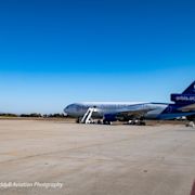
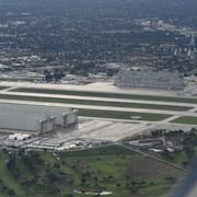
Coordinates: 37°27′40″N 122°06′54″W. Bird's-eye view of the facilities. Palo Alto Airport ( IATA: PAO, ICAO: KPAO, FAA LID: PAO) is a general aviation airport in the city of Palo Alto in Santa Clara County, California, United States, near the south end of San Francisco Bay on the western shore. [1] Facilities.
Local airports near Palo Alto, CA. 2 miles to: Palo Alto, CA (PAO / KPAO) Palo Alto Airport of Santa Clara County; 7 miles to: Mountain View, CA (NUQ / KNUQ) Moffett Federal Airfield; 11 miles to: San Carlos, CA (SQL / KSQL) San Carlos Airport; 21 miles to: Hayward, CA (HWD / KHWD) Hayward Executive Airport
May 16, 2024 · Complete aeronautical information about Palo Alto Airport (Palo Alto, CA, USA), including location, runways, taxiways, navaids, radio frequencies, FBO information, fuel prices, sunrise and sunset times, aerial photo, airport diagram.
- 6.8 ft. / 2.1 m (surveyed)
- 15E (1995)
- PAO
Palo Alto: PAO: PAO KPAO Palo Alto Airport of Santa Clara County: R 14 Petaluma: O69: Petaluma Municipal Airport: R 2 Ramona: RNM: KRNM Ramona Airport: R 0 Riverside: RAL: RAL KRAL Riverside Municipal Airport: R 4 Sacramento: SAC: SAC KSAC Sacramento Executive Airport: R 57 Sacramento: MHR: MHR KMHR Sacramento Mather Airport: R 420 San ...
Palo Alto Airport (PAO) located in Palo Alto, California, United States. Airport information including flight arrivals, flight departures, instrument approach procedures, weather, location, runways, diagrams, sectional charts, navaids, radio communication frequencies, FBO and fuel prices, hotels, car rentals, sunrise and sunset times, aerial ...
The nearest airport to Palo Alto is San Carlos (SQL). However, there are better options for getting to Palo Alto. Amtrak operates a train from Sacramento to Santa Clara Amtrak every 4 hours. Tickets cost $5 - $85 and the journey takes 2h 52m. Recommended airport. San Francisco (SFO) 1h 11m. $12–16. See schedules. Other nearby airports.
Palo Alto Airport of Santa Clara County (IATA: PAO, ICAO: KPAO, FAA LID: PAO) is a general aviation airport in the city of Palo Alto in Santa Clara County, California, USA, near the south end of San Francisco Bay on the western shore.


Ads
related to: palo alto california airports locationAirports Near California. Book the Best Flight to Your Next Destination and Save! Compare 100s of Flights & Airline Tickets. Your Shortcut to the Best Travel Deals.
Compare Prices & Save Money With Tripadvisor (The World's Largest Travel Site). Tripadvisor Checks Up To 200 Sites To Help You Find The Lowest Prices.