Search results
People also ask
Where is Palo Alto Airport?
What are the closest airports to Palo Alto?
Where is Palo Alto California?
How big is Palo Alto Airport?
Local airports near Palo Alto, CA. 2 miles to: Palo Alto, CA (PAO / KPAO) Palo Alto Airport of Santa Clara County; 7 miles to: Mountain View, CA (NUQ / KNUQ) Moffett Federal Airfield; 11 miles to: San Carlos, CA (SQL / KSQL) San Carlos Airport; 21 miles to: Hayward, CA (HWD / KHWD) Hayward Executive Airport
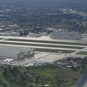
Coordinates: 37°27′40″N 122°06′54″W. Bird's-eye view of the facilities. Palo Alto Airport ( IATA: PAO, ICAO: KPAO, FAA LID: PAO) is a general aviation airport in the city of Palo Alto in Santa Clara County, California, United States, near the south end of San Francisco Bay on the western shore. [1] Facilities.
May 16, 2024 · Complete aeronautical information about Palo Alto Airport (Palo Alto, CA, USA), including location, runways, taxiways, navaids, radio frequencies, FBO information, fuel prices, sunrise and sunset times, aerial photo, airport diagram.
- 6.8 ft. / 2.1 m (surveyed)
- 15E (1995)
- PAO
Palo Alto Airport (PAO) located in Palo Alto, California, United States. Airport information including flight arrivals, flight departures, instrument approach procedures, weather, location, runways, diagrams, sectional charts, navaids, radio communication frequencies, FBO and fuel prices, hotels, car rentals, sunrise and sunset times, aerial ...
1. All. Price. Open Now. Free Wi-Fi. Open to All. 1 . Palo Alto Airport. 3.7 (13 reviews) Airports. This is a placeholder. “I always like to see airplanes and see planes flying, plus this airport is located next to the...” more. 2 . San José Mineta International Airport. 3.7 (2.3k reviews) Airports. North San Jose. This is a placeholder.
Palo Alto Airport of Santa Clara County (IATA: PAO, ICAO: KPAO, FAA LID: PAO) is a general aviation airport in the city of Palo Alto in Santa Clara County, California, USA, near the south end of San Francisco Bay on the western shore.
Enroute Charts at SkyVector.com. Location Information for KPAO. Coordinates: N37°27.67' / W122°6.90'. Located 00 miles E of Palo Alto, California on 102 acres of land. View all Airports in California. Surveyed Elevation is 6 feet MSL. Operations Data. Airport Use: Open to the public.