Search results
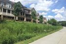
The Easiest Way to Access EastSide Destinations. A combination of multi-use trail and linear greenspace, the Eastside Trail was the first finished section of the Atlanta BeltLine trail in the old rail corridor.
People also ask
Where is the Atlanta BeltLine Eastside Trail?
What is the Eastside BeltLine trail?
What is the Atlanta BeltLine trail?
What parks are connected to the Atlanta BeltLine?
Use this Atlanta BeltLine Eastside Trail map to explore the city’s eastside. Find restaurants, rooftop bars, breweries, food halls and attractions on the Eastside Trail.
The Atlanta BeltLine is a visionary project on a grand magnitude, aimed at transforming transportation and outdoor enjoyment in Atlanta. When completed, the project will produce a 33-mile, multi-use trail connecting 45 of Atlanta’s in-town neighborhoods along a former railroad corridor.
Jun 13, 2024 · Meander through Atlanta's neighborhoods and make pitstops to eat, drink and be merry on this self-guided tour of the BeltLine Eastside Trail.
- Trail Distance
- Access Points
- Bonus Trails
The Atlanta BeltLine Westside Trail stretches three miles from Washington Park (Lena Street) to University Avenue.
Access points are located near Washington Park, Gordon White Park and Adair Park. Other access points are located at the Lee+White development. Within the MARTA rail system, the Ashby station is located on the Westside Trail’s northern end, and the southern end is a few minutes from the West End and Oakland City stations.
The Westside Trail connects to the Southwest Connector Trail, which extends all the way to historic Westview Cemetery. At Washington Park, the Westside Trail connects to the Lionel Hampton Trail, which meanders west through beautiful green space. The West End Trail hooks up to the Westside Trail and stretches from Rose Circle Park through Gordon Wh...
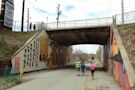
The Eastside Trail is 2 miles in length from 10th Street & Monroe Drive to Irwin Street. Connects Piedmont Park, Atlanta Botanical Garden, Historic Fourth Ward Park, the Stone Mountain Trail, and Freedom Park. The southern extension, between Irwin Street and Kirkwood Avenue, is under construction through 2017.
Closest entry point: Eastside Trail - 10th Street and Monroe Drive. One of the city's most iconic bars is Park Tavern, which overlooks Atlanta's largest green space, Piedmont Park. It hosts events like live music and ice skating as well as an epic Peachtree Road Race after-party on July 4.