Search results
Experience this 2.7-mile out-and-back trail near Big Bear Lake, California. Generally considered a moderately challenging route, it takes an average of 1 h 38 min to complete. This is a very popular area for hiking, so you'll likely encounter other people while exploring.
Want to find the best trails in Castle Rock State Park for an adventurous hike or a family trip? AllTrails has 16 great trails for hiking and more. Enjoy hand-curated trail maps, along with reviews and photos from nature lovers like you.
Video and turn-by-turn directions to hike the Castle Rock Trail in Big Bear, including parking info, insider tips, and a short side trip to Bluff Lake.
4 days ago · The park’s 34 miles of rugged trails conveniently connect to an extensive trail system that links the Santa Clara and San Lorenzo valleys to nearby Big Basin Redwoods State Park and open space preserves on the Skyline to the Sea Trail.
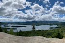
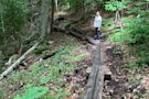
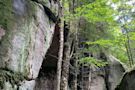
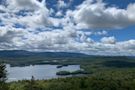
The Castle Rock Trail is one of Big Bear's most popular trails. The trail begins 1 mile east of Big Bear Dam on Hwy 18. On the south side of Hwy 18 is a small brown sign that marks the trailhead.
Head out on this 10.9-mile loop trail near Los Gatos, California. Generally considered a challenging route. This is a very popular area for hiking and running, so you'll likely encounter other people while exploring. The trail is open year-round and is beautiful to visit anytime.
The trail passes through an old mixed conifer forest, crossing Cougar Creek and continuing northeast to Forest Road 480. The trail crosses the road and sidehills west up the southeast side of Castle Rock.