Search results
PED/BI BRIDGE 1/8 Mile Hays Tree Garden Cuthberti Amphi- theater Community Garden Native Plant Nursery 250 Feet EUGENE WHILAMUT AREA KNICKERBOCKER PED/BIKE BRIDGE University of Oregon AUTZEN PED/BIKE BRIDGE Millrace x St w D St Springfield ODLAND. Title. Alton Baker Park Map. Created Date. 3/26/2009 3:03:46 PM.
Easy • 4.5 (163) Alton Baker Park. Photos (306) Directions. Print/PDF map. Share. More. Length 3.4 miElevation gain 55 ftRoute type Loop. Experience this 3.4-mile loop trail near Eugene, Oregon. Generally considered an easy route, it takes an average of 1 h 1 min to complete.
- (164)
- Eugene, Oregon, United States
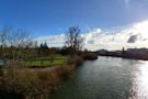
Directions. Satellite. Photo Map. Notable Places in the Area. Dave and Lynn Frohnmayer Pedestrian and Bicycle Bridge. Bridge. Photo: Chris Phan, CC BY 2.0.
Want to find the best trails in Alton Baker Park for an adventurous hike or a family trip? AllTrails has 6 great trails for walking and birding and more. Enjoy hand-curated trail maps, along with reviews and photos from nature lovers like you.
- (1.2K)
- Oregon, United States
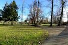
Description. Alton Baker Park, Eugene’s largest developed park, is home to dozens of recreational features and facilities serving the City of Eugene since 1959. The park is made up of two major areas: the more developed West Alton Baker Park, and the 237-acre Whilamut Natural Area.
Jan 18, 2024 · Alton Baker Park. Eugene , Willamette Valley. Eugene, Oregon 97402. 541.682.4800. This listing is provided by Eugene, Cascades & Coast. Comprising of 402 acres (163 ha), Eugene’s largest riverfront park comes alive throughout the year with festivals, running and walking races and community events.
This popular 400-acre riverside park, which provides access to the Ruth Bascom Riverbank Trail System, a 12-mile bikeway that flanks both sides of the…

 Alton Baker Park Map - Eugene, Oregon - DOKUMEN.TIPS")


 at city ...")