Search results
Mar 26, 2024 · Baltimore. Patapsco River. The ship left the Port. of Baltimore around. 1 a.m. on Tuesday. Francis Scott. Key Bridge. The ship hit the bridge at 1:28 a.m. 1 mile. Francis Scott. Key...
- Weiyi Cai
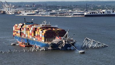
Coordinates: 39°12′56″N 76°31′47″W. On March 26, 2024, at 1:28 a.m. EDT (05:28 UTC ), the main spans and the three nearest northeast approach spans of the Francis Scott Key Bridge across the Patapsco River in the Baltimore metropolitan area of Maryland, United States, collapsed after the container ship Dali struck one of its piers.
Coordinates: 39°13′1″N 76°31′42″W. The Francis Scott Key Bridge under construction in 1976. Sign for the Key Bridge used on approach roads. The Francis Scott Key Bridge (informally, Key Bridge or Beltway Bridge) is currently a partially collapsed bridge that is in the process of being rebuilt.
Mar 26, 2024 · A cargo ship hit a bridge support and caused the bridge to collapse, sending vehicles and people into the water. See maps, video and photos of the site and the ship's route.
- kerry.breen@paramount.com
- Paula Cohen,Kerry Breen
- 2 min
Mar 26, 2024 · The bridge crosses over the Patapsco River on I-695 and is the final link on the Baltimore Beltway. It was built in 1977 and named after Francis Scott Key, who wrote the Star Spangled Banner near the site.
The 1.6 mile Key Bridge crosses over the Patapsco River where Francis Scott Key was inspired to write the words of the Star Spangled Banner. This facility also includes the Curtis Creek Drawbridge. Including the bridge and approach roadways, the facility is approximately 10.9 miles in length. Get E-ZPass:
Mar 26, 2024 · USA TODAY. Two bodies were found in a red pickup truck in 50-foot-deep water beneath the middle span of the Francis Scott Key Bridge near Baltimore Wednesday. The search continues for four...

