Search results
2 days ago · The map above shows the approximate fire perimeter as a black line and the evacuation zones in red. For more evacuation details and latest updates, see Santa Barbara County’s emergency map .
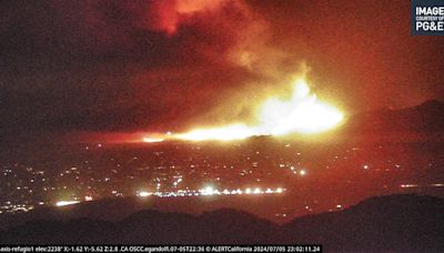
3 days ago · Date Started. 07/05/2024 3:48 PM. Location Information. Santa Lucia Road near Zaca Lake. Latitude / Longitude. [34.785,-120.044833] Admin Unit. Los Padres National Forest. Incident Management Team.
6 hours ago · By Alexandra E. Petri. July 7, 2024, 8:05 p.m. ET. A wildfire that erupted in the mountains of Santa Barbara County in Southern California has burned more than 16,000 acres, prompting an ...
The Santa Barbara County Fire Department is a progressive, multi-mission public safety agency with a rich tradition and history. We stand ready to serve the people of this world-renowned area with professionalism, dedication, and pride.
1 day ago · Quick links: Lake Fire evacuations and road closures; Air Quality Watch issued in Santa Barbara County; UPDATE (4:34 p.m.) - A new Evacuation Warning has been issued for the areas north of Calzada ...
8 hours ago · A wildfire in the mountains above Santa Barbara County’s Santa Ynez Valley has exploded to more than 16,000 acres, prompting evacuations near vineyards and Neverland Ranch. The Lake fire was ...
3 hours ago · July 7, 2024 / 7:57 PM PDT / KCAL News. Firefighters are continuing an uphill battle in Santa Barbara County, where the Lake Fire swelled to more than 16,000 acres over the weekend. The blaze was ...


