Search results
Discover more placesNear Lawrenceville, GA
Refine results for Airports
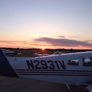
The Gwinnett County Airport – Briscoe Field is located on approximately 500 acres northeast of the city of Lawrenceville. The airport has a single 6,000-foot-long by 100-foot-wide grooved asphalt runway, capable of handling all light general aviation aircraft and most corporate jet aircraft in operation today.
This is the homepage for KLZU, the Gwinnett County Airport located in Lawrenceville, GA. For current EAA news, please visit our local chapter's website: www.eaa690.org For Covington (9A1), visit www.eaa1025.org
Gwinnett County Airport (IATA: LZU, ICAO: KLZU, FAA LID: LZU) at Briscoe Field is a municipal airport located about two miles (3 km) northeast of Lawrenceville, Georgia and about 30 miles northeast of Downtown Atlanta. It is owned and operated by the Gwinnett County, in northeastern metro Atlanta.
- 82,895
- 80
May 16, 2024 · Complete aeronautical information about Gwinnett County Airport-Briscoe Field (Lawrenceville, GA, USA), including location, runways, taxiways, navaids, radio frequencies, FBO information, fuel prices, sunrise and sunset times, aerial photo, airport diagram.
ICAO: KLZU. FAA: LZU. Lawrenceville, Georgia, United States. View AFD. Airport Info. Flight Info. Travel Guides. AirportGuide.com may earn a commission for any sales placed through links on this free web site. For more info see https://paidforadvertising.com. + -
- 1061.5 feet MSL (324 m MSL)
- 083-57-44.5100W (-83.962364)
- 33-58-41.1310N (33.978092)
- 5.8 W (as of April 2024 from WMM2020 model)
There are 5 ways to get from Lawrenceville to Atlanta Airport (ATL) by bus, subway, taxi, car, or towncar. Select an option below to see step-by-step directions and to compare ticket prices and travel times in Rome2rio's travel planner. Recommended option. Line 40 bus, bus, subway • 2h 32m. 40. 10A / ... Cheapest option. Drive • 49 min. 42.2 mi.
Location Information for KLZU. Coordinates: N33°58.69' / W83°57.74' Located 02 miles NE of Lawrenceville, Georgia on 520 acres of land. View all Airports in Georgia. Surveyed Elevation is 1061 feet MSL. TPA FOR LIGHT ACFT 1039 FT; TPA FOR JET & TURBO PROP ACFT 1539 FT. Operations Data. Airport Communications. Nearby Navigation Aids. Runway 07/25.


 | Arrivals, Departures ...")


