Search results
Apr 25, 2024 · Find various maps of Mount Rainier National Park and its vicinity, including campgrounds, trails, wilderness, and aviation hazards. Download or view the maps in PDF format or explore the park virtually.
- Alerts & Conditions
Mount Rainier National Park would like to provide...
- Campgrounds
Campgrounds at Mount Rainier. Click on the campground name...
- Park Brochure
A detailed map of Mount Rainier National Park showing roads,...
- Mount Rainier
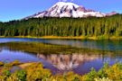
Ascending to 14,410 feet above sea level, Mount Rainier...
- Alerts & Conditions
- Mount Rainier Map from The Park Brochures
- Mount Rainier Trail Maps
- Mount Rainier Hiking Maps
- Mount Rainier Lodging Map
- Paradise Area Maps
- Mount Rainier Topographic Maps
- Mount Rainier Geologic Maps
- Mount Rainier Campground Maps
- Mount Rainier Night Sky Map
- Mount Rainier Map Prints and Gifts
- GeneratedCaptionsTabForHeroSec
Here’s the official revised Mount Rainier map from 2015, which includes minor updates at the expense of a much larger PDF file size. Click the image to view a full size JPG (2.5 mb) or download the PDF (16.9 mb). This is the main Mount Rainier National Park map from the park brochure, showing roads, major trails, and points of interest. Click the i...
If you want a full color waterproof trail map with topographic lines, you should probably purchase the National Geographic Trails Illustrated map. The free maps below work well for trip planning and for short hikes, but aren’t going to be too useful for overnight wilderness trips. This map includes mileages, backcountry campgrounds, and detailed to...
The following maps are from trailhead wayside exhibits throughout the park. This Paradise area trails map(500 kb) is from a sign at the Paradise parking lot. It shows the entire network of trails that view the Nisqually Glacier, Paradise Glacier, Myrtle Falls, and Panorama Point. The Pinnacle Peak trail map(90 kb) shows the route to the top of (wha...
If you want to stay just outside Mount Rainier National Park, your closest bet will be the town of Ashford; to the right you can open a Hotels.com interactive lodging map centered there. Zooming out will show other lodging options in nearby towns, though they’re all further away. Instead, you may be best off browsing Hotels.com’s top-rated Mount Ra...
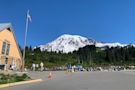
Here’s a current Paradise map(150 kb), taken from a wayside exhibit in front of the Paradise Visitor Center. This will help you get oriented between the visitor center, Paradise Inn, and parking areas. This is a historic Paradise map(180 kb), located on the wayside next to the Paradise Inn. It shows the former locations of buildings from earlier da...
This Mount Rainier East topo map focuses on the southeast side of Mount Rainier and includes the Paradise developed area. Click the image to view a full size JPG (3.3 mb) or download the PDF (17.6 mb). The Mount Rainier West topo map includes the Mount Rainier summit and the glaciers and features on the mountain’s southwest side. Click the image to...
Here’s a bedrock geology map of Mount Rainier (2.1 mb), showing the various volcanic rocks that make up the foundation of Mount Rainier and the surrounding lands throughout the national park. This is a Mount Rainier geologic mapof surficial geology (2.1 mb), showing mudflows and other more-recent features that appear on the ground surface, overlyin...
This is a Cougar Rock Campground map. Cougar Rock is located between Longmire and Paradise in the southwest corner of the park. Click the image to view a full size GIF (200 kb) or download the PDF (200 kb). This is a map of Ohanapecosh Campground, which is located near the Ohanapecosh Visitor Center in the southeast corner of the park. Click the im...
The Mount Rainier night sky map(350 kb) shows how Mount Rainier National Park’s dark skies compare to locations in Seattle, Tacoma, Yakima, and throughout the Puget Sound region.
Printed high-resolution Mount Rainier map posters and other products are available at the Mount Rainier Maps store. For prints, gift ideas, and souvenirs featuring other national parks, support this site and visit the National Park Maps store; you’ll find items to bring on vacation, keep at home for the memories, or give to your park-enthusiast fri...
Find 28 free Mount Rainier National Park maps to view and download, covering trails, campgrounds, roads, and more. Browse the best-selling Mount Rainier maps and guidebooks on Amazon or shop for high-quality art prints and posters.
Learn about the history, activity, and threats of Mount Rainier, the highest peak in the Cascade Range. Find news, publications, and maps related to volcanic hazards and monitoring at this active andesitic volcano.
Coordinates: 46°51′N 121°45′W. Mount Rainier National Park is an American national park located in southeast Pierce County and northeast Lewis County in Washington state. [3] .
Learn about the history, attractions, and hiking trails of Mount Rainier National Park, an active volcano and the tallest mountain in Washington state. See stunning photos and maps of the park and its features.