Search results
People also ask
How high is Mount Elbert in Colorado?
How do you hike Mount Elbert?
Is Mount Elbert A good hike?
Where is the best place to hike Mount Elbert in winter?
There are two main routes to the summit, which are the South Mt. Elbert Trail and the North (Main) Mt. Elbert Trail, both being well trodden class one trails. These relatively easy paths to the summit are busy in the summer, attracting all types of hikers and climbers.
May 10, 2020 · Done as a day trip, the Mount Elbert hike time for most people is around 6-8 hours round-trip (depending on how many breaks you take). Here’s everything you need to know about Mount Elbert to reach its summit safely and successfully using the North Mount Elbert Trail via the Northeast Ridge route.
- Trails
- Trail Map
- Hiking Mount Elbert in Winter
- Camping For Mount Elbert
- Current Weather Conditions
North Mount Elbert Trail: 8.8 Miles Round Trip | 4,530 Feet Elevation Gain | Class 1
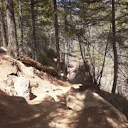
This is the most common route up Mount Elbert. It features a very steady gain all the way to the summit, and is a very highly trafficked trail. There are countless dispersed campsites along the road near the trailhead, as well as established campgrounds. The hike begins in the woods and steadily rises to treeline. It is easy to follow, in great condition, and features a few false summits. hikers reach treeline 2.9 miles into the hike. From here, most of the hike is visible via the ridge, and...
South Mount Elbert Trail (4WD Vehicle): 8.8 Miles Round Trip | 4,100 Feet Elevation Gain | Class 2
This route begins near Twin Lakes Reservoir, and is frequently trafficked. The dirt road is accessible for most 4WD vehicles. This is actually the easiest route to the summit, is easy to follow, and features a steady elevation gain to the summit. Road Conditions:During the winter the 4WD road is not accessible by car.
South Mount Elbert Trail (2WD Vehicle): 12.4 Miles Round Trip | 5,000 Feet Elevation Gain | Class 2
This is the same route as above just with added distance and some road walking. In the winter, the road to the 4WD is often impassable, making it necessary from starting at this trailhead.
The below map shows the standard route, mileage markers, elevation markers, and more for the North Mount Elbert Trail and the South Mount Elbert Trail. Want this trail map? Here is the link.
Either route above can be accomplished in winter. Of course, the right gear and preparation is needed to summit Elbert in winter. During winter the South Mount Elbert 2WD trailhead will be your best starting point as it only ads 1.8 miles on the road. The road to the North Mount Elbert trail is closed in winter.
The North Elbert trail features tons of dispersed campsites near the trailhead. This is an awesome location to spend the night. There are also two National Forest campgrounds; Halfmoon East Campground & Elbert Creek Campground, located on Halfmoon road right next to the trailheads for Mount Massive and Mount Elbert. Elbert creek has RV sites for le...
Here is the detailed weather forecast for the next few days. We highly recommend you check out the mountain forecast for this region the morning of your hike.
Hiking Elbert's east ridge. Elbert seen from Mt. Massive. Sawatch peaks from Mt. Yale to Mt. Massive. Elbert is right of center. La Plata Peak, Mt. Elbert and Mt. Massive seen from Mt. Bross. Elbert seen from the east. Elbert from 13er Mount Sheridan. A fall hike of Mount Elbert. Elbert and Mount Massive seen from the east.
Limber Pine Trail. Preparing for Your Hike. Essential Gear and Supplies. Safety Tips and Guidelines. Leave No Trace Principles. Additional Outdoor Activities in Elbert. Rock climbing. Fishing. Camping. Conclusion. Exploring the Natural Landscape of Elbert. Home to the highest peak in Colorado, Elbert is an excellent spot for nature enthusiasts.
Colorado / San Isabel National Forest / Mount Elbert Loop via Colorado and Mt Elbert Trail. Hard • 4.8 (66) San Isabel National Forest. Photos (5,734) Directions. Print/PDF map. Share. More. Length 14.2 miElevation gain 4,996 ftRoute type Loop. Proceed cautiously on this 14.2-mile loop trail near Leadville, Colorado.