Search results
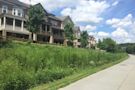
The Easiest Way to Access EastSide Destinations. A combination of multi-use trail and linear greenspace, the Eastside Trail was the first finished section of the Atlanta BeltLine trail in the old rail corridor. The Eastside Trail, which was funded by a combination of public and private philanthropic sources, runs from the tip of Piedmont Park ...
The Atlanta BeltLine Eastside trail is the most established area on the BeltLine with many restaurants, rooftop bars, breweries, food halls and attractions on the trail. Stretching from Piedmont Park in Midtown to Reynoldstown east of the city, the journey is full of beautiful views, great food, and street art. 1. Piedmont Park. You can’t ...
People also ask
Where is the Atlanta BeltLine Eastside Trail?
What is the Eastside BeltLine trail?
What is the Atlanta BeltLine trail?
Can you walk the Eastside Trail in Atlanta?
The Eastside BeltLine Trail is a level grade, wide swath of pavement that departs Midtown Atlanta at the southeast corner of Piedmont Park.Grab time on the trail on a fair-weather weekend, and the catalyst for the BeltLine’s positive intown buzz becomes quickly apparent: walkers, runners, cyclists, skaters, and strollers pack the trail, enjoying some sunshine, catching some cardio, or ...
- Trail Distance
- Access Points
- Bonus Trails
The Atlanta BeltLine Westside Trail stretches three miles from Washington Park (Lena Street) to University Avenue.
Access points are located near Washington Park, Gordon White Park and Adair Park. Other access points are located at the Lee+White development. Within the MARTA rail system, the Ashby station is located on the Westside Trail’s northern end, and the southern end is a few minutes from the West End and Oakland City stations.
The Westside Trail connects to the Southwest Connector Trail, which extends all the way to historic Westview Cemetery. At Washington Park, the Westside Trail connects to the Lionel Hampton Trail, which meanders west through beautiful green space. The West End Trail hooks up to the Westside Trail and stretches from Rose Circle Park through Gordon Wh...
BeltLine Eastside Trail via Piedmont Park. Check out this 4.6-mile point-to-point trail near Atlanta, Georgia. Generally considered an easy route, it takes an average of 1 h 30 min to complete. This is a very popular area for road biking, running, and walking, so you'll likely encounter other people while exploring.
- (870)
- Atlanta, Georgia, United States
Multi-use trail portion is 1.15 miles in length. Using a 33-mile network of multi-use trails, the Atlanta BeltLine is creating a new public realm – offering a pedestrian-friendly environment which promotes walking, jogging, biking, and affordable housing. In its final phases, it will include a 22-mile continuous corridor, as well as numerous ...
Closest entry point: Eastside Trail - Irwin Street. Kevin Rathbun and his restaurants have been a part of the Inman Park community since before the Eastside Trail's completion. Start at Kevin Rathbun Steak, which has been open since 2007. The fine dining eatery has a menu of dishes like dry-aged steak, rack of lamb, and truffle parmesan fries.


, including the ...")