Search results
This trail begins from the Fallen Leaf Campground and follows along the shoreline of Fallen Leaf Lake. There are beautiful lake and forest views along the way. The trail can be overgrown in sections, and downloading offline maps can help navigate these sections.
- Fallen Leaf Lake via Sand Harbor Trail - AllTrails
Fallen Leaf Lake via Sand Harbor Trail. Experience this...
- Fallen Leaf Lake, Lake Aloha, and Mount Tallac Loop - AllTrails
Explore this 15.8-mile loop trail near South Lake Tahoe,...
- Fallen Leaf Lake via Sand Harbor Trail - AllTrails
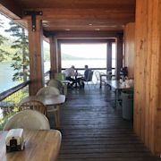
Fallen Leaf Campground is situated on the north shore of Fallen Leaf Lake and adjacent to Taylor Creek. The south shore of Lake Tahoe is less than a mile away. The campground features 206 sites that include six yurts and standard tent and RV sites.
- (530) 544-0426
- Fallen Leaf Campground, California
Fallen Leaf Lake Campground is located on the south side of Lake Tahoe, approximately three miles north of the "Y" (the intersection of Highway 50 and Highway 89) in South Lake Tahoe. The campground entrance can be accessed by turning off Highway 89 onto Fallen Leaf Lake Road.
- For reservations, visit www.recreation. gov.
- Heavy
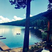
Fallen Leaf Lake is a mountain lake located in El Dorado County, California, near the California–Nevada state border, about one mile south west of the much larger Lake Tahoe.
Fallen Leaf Lake is a mountain lake located in El Dorado County, California, near the California–Nevada state border, about one mile south west of the much larger Lake Tahoe. It is approximately aligned north-to-south and oval in shape, measuring approximately 2.9 miles (4.6 km) on the long axis and 0.9 miles (1.4 km) on the short axis.
People also ask
Where is Fallen Leaf Lake?
Where is Fallen Leaf campground?
How much does it cost to park at Fallen Leaf Lake?
Is Fallen Leaf Lake open on Memorial Day?


 | Tahoe Trail Guide")


