Search results
Apr 25, 2024 · The map of Mount Rainier National Park above can be toggled between "Standard Map" or "Brochure Map" using the drop down menu in the upper left corner. Maps of Park and Vicinity. Maps of Mount Rainier Campgrounds. Maps of Mount Rainier Wilderness and Trails.
Need a Mount Rainier map? Here I've collected 28 free high-resolution Mount Rainier National Park maps to view and download: roads, hiking trails, and more!
Jun 5, 2023 · A detailed map of Mount Rainier National Park showing roads, trails, and visitor areas with amenities. The map is focused on the area within the park boundary, with a minimum of information on the areas immediately outside of the park.
Apr 11, 2024 · Print or download trail maps and other brochures before your visit. All this and more can be found under Basic Information. Directions & Transportation. Directions to the park's five entrances from the surrounding areas, as well as maps of the park. Eating and Sleeping.
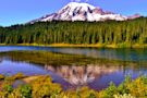
Nov 22, 2021 · Use this PDF map to get your bearings on Mount Rainier’s main entrances, park roads, lakes, waterfalls and hiking trailheads. Noted are the most popular regions of the park including Paradise, Longmire, Ohanapecosh, Carbon River and Sunrise.
Feb 5, 2024 · Map of Mount Rainier National Park: Click to see large. Description: This map shows peaks, glaciers, rivers, lakes, roads, hiking trails, interpretive trails, Pacific Crest Trail, Wonderland Trail, former road open to bikers and hikers, ranger stations, wilderness patrol cabins, lodging, campgrounds, restaurants, groceries, picnic areas ...
Check out these helpful trail maps with descriptions, and average hiking times provided by Mount Rainier National Park. Click on the images below to get a free PDF copy.
Jun 3, 2011 · Round-Trip: 93-Mile Loop. Level: Challenging Backpacking Trip to Complete the Loop; Moderate Backpacking Trip For Sections. A ten-day (minimum) circumnavigation of massive Mount Rainier is one...
Mount Pleasant 6454ft 1967m Fay Peak 6492ft 1979m Knapsack Pass Tirzah Peak 5208ft 1587m Wallace Peak Tyee Peak Pacific Point Natural Bridge Redstone Peak Pigeon Peak Sluiskin ... MOUNT RAINIER RUSSELL CLIFF DISAPPOINTMENT CLEAVER GLACIER BASIN OHANAPECOSH PARK INDIAN BAR BOX CANYON THE BENCH COWLITZ PARK MEANY CREST YAKIMA PARK BERKELEY PARK ...
Apr 14, 2024 · Best hikes in Mount Rainier National Park, plus map, photos, best time to go hiking in Mount Rainier, recommendations for hiking with kids.