Search results
People also ask
What is a high-risk outlook for severe weather?
What is an example of a high risk severe weather outlook?
What are severe weather forecasters worried about?
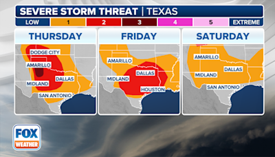
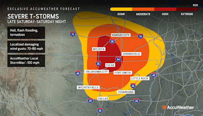
Today's Convective Outlooks: Updated: Sun May 26 17:33:01 UTC 2024: Current Convective Outlooks; Current Day 1 Outlook: Forecaster: Bunting/Squitieri Issued: 26/1640Z Valid: 26/1630Z - 27/1200Z Forecast Risk of Severe Storms: Enhanced Risk: Current Day 2 Outlook: Forecaster: Bentley Issued: 26/1729Z Valid: 27/1200Z - 28/1200Z
- 0100 Utc Day 1 Outlook
0100 Utc Day 1 Outlook - Storm Prediction Center Convective...
- Watches
Watches - Storm Prediction Center Convective Outlooks
- 2022 0730 Utc Day 3 Severe
2022 0730 Utc Day 3 Severe - Storm Prediction Center...
- Storm Reports
Severe Plot is SPC's web-based mapping for storm reports...
- PWO
PWO - Storm Prediction Center Convective Outlooks
- Print Version
Print Version - Storm Prediction Center Convective Outlooks
- Noaa/Nws Storm Prediction Center
Another area of significant severe weather potential will...
- All Forecasts
Today's Outlook: This is tomorrow's forecast for organized...
- 0100 Utc Day 1 Outlook
- Synopsis
- Southern Plains/Ks to The Mid-South Vicinity
- Northern/Central Plains
- KY/TN to The Mid-Atlantic
- Northeast
Enhanced west/southwesterly flow will spread across the southern Plains to the Lower MS Valley and Mid-Atlantic vicinity on Thursday. One upper shortwave impulse is forecast to eject from the southern Rockies to the Mid-South, while another subtle impulse moves from the TN Valley vicinity to the Carolinas. To the north, a negatively tilted compact ...
A very moist airmass will develop by midday, with surface dewpoints in the upper 60s to near 70 F common. Steep midlevel lapse rates atop this very moist boundary layer will foster strong to extreme instability with MLCAPE from 2500-4500 J/kg evident in forecast soundings. Thunderstorms may develop across parts of AR into the Mid-South vicinity by ...
Thunderstorms are expected to develop in the vicinity of the deepening surface low over the Dakotas southward along the east/southeast-progressing cold front. Low-level moisture will remain modest with northward extent across the Dakotas into western MN, with higher-quality moisture expected over NE. However, steep midlevel lapse rates will be pres...
A subtle shortwave trough will spread east across the region as boundary-layer moisture increasing amid strengthening southerly low-level flow. Clusters of thunderstorms may pose a risk of hail and gusty winds across parts of KY/TN. With eastward extent into VA and the Carolinas, thunderstorm coverage will be higher. Clusters of storms may develop ...
A surface cold front will shift east across the region during the day before moving offshore by early evening. Surface dewpoints in the low 60s and steep midlevel lapse rates will support MLCAPE values around 1000-2000 J/kg. Low-level flow will remain weak, but fast mid/upper westerly flow will support elongated/straight hodographs. Thunderstorms m...
May 6, 2024 · May 06, 2024. At a Glance. NOAA's Storm Prediction Center issues outlooks for severe weather every day. High-risk outlooks are rare. They indicate either a tornado outbreak or widespread...
Mar 16, 2020 · Many meteorologists use the NOAA/Storm Prediction Center severe thunderstorm outlooks for severe weather guidance. These outlooks use severe risk categories, ranging from "marginal" to...


