Search results
This is a gorgeous and challenging hike that travels through the heart of Phoenix Mountains Park. Many hikers visit Piestewa Peak for its proximity to Phoenix but be prepared for crowds and parking challenges. Getting an early start on the trail is suggested to beat the heat. Make sure to bring plenty of water. Although dogs are allowed in the area, they are not permitted on the Piestewa ...
- (1.8K)
- Phoenix, Arizona, United States
- Quick Stats
- How Tall Is Piestewa Peak?
- How Long Does It Take to Climb Piestewa Peak?
- How Difficult Is The Piestewa Peak Hike?
- Is The Piestewa Peak Hike Harder Than Camelback?
- How Long Is The Piestewa Peak Trail?
- Can Kids Hike Piestewa Peak?
- Are Dogs Allowed on Piestewa Peak Trail?
- How Do You Pronounce Piestewa?
- Where Do You Park For Piestewa Peak?
With over 240 trails in Phoenix, Piestewa Peak hike via the Summit Trail easily ranks as one of our Top 5 trails in the Valley, but it’s one of the more challenging hikes, so there’s a lot you need to know before you go! As a family of four, we know what it’s like to attempt this hike, without being fully prepared, and struggle our way through. We ...
Piestewa Peak, formerly named Squaw Peak, has the second-highest peak in the proper city of Phoenix. At 2,608 feet high, only Camelback Mountainhas a higher peak. Both mountains are in the Phoenix Mountains Preserve and are located just east of Arizona State Highway 51 (Piestewa Peak) and between Lincoln Drive and Northern Avenue. Piestewa Peak is ...
From start to finish, this trail took us 2 hours, 2 minutes, and 30 seconds to hike. Due to its stair-step-style terrain, some hikers will require a few moments to stop and catch their breath. Also, since the views are so breathtaking, it’s easy to want to spend as much time at the top as possible. The great views and easy access from the city also...
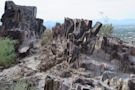
Piestewa Peak has signage at the trailhead that indicates it’s a double-black-diamond “Extremely Difficult” rated trail. If you’re typically searching for a longer hike, you might overlook Piestewa for its lack of distance, but the constant rapid elevation gain, terrain, traffic, (and of course) Arizona’s summer temperatures make it a very difficul...
Piestewa Peak and Camelback are frequently compared to each other because of their similar peak elevation, similar trail distance, and close proximity to the city. We’ve hiked both of these peaks in the winter and the summer and Camelback is the most difficult, though not dramatically. The slight distance increase with Camelback is what creates the...
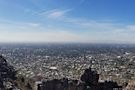
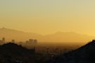
The Piestewa Peak hike via the Summit Trail is 2.1 miles in an out-and-back-formation. For such a relatively short hike in the Valley, Piestewa’s Peak offers amazing views of downtown Phoenix, and the cities of Mesa, Chandler, and Scottsdale.
Our family ages are 36, 33, 12, and 9 as we write this post, so Piestewa is suitable for at least people of that age group (who also write or star in weekly blogs about their most recent hikes). While our kids do hike more than probably most kids, I think most kids would have the energy and desire to finish this hike. Though our kids are 12 and 9 n...
Piestewa Peak is probably one of the more informative trails as it relates to signage. At the many trailheads are many descriptive signs. All of the roadside trailheads meet at a formal trailhead including a sign stating dogs are not allowed on this trail. Drones and bikes are also not allowed on the trail.
As somewhat of a Phoenix newcomer, we’ve heard Piestewa pronounced in many ways. Previous to writing this post, I’m fairly confident that I pronounced it incorrectly. The correct pronunciation is: pai-eh-stoo-uh (par-k). Google’s Pronunciation of Piestewa
As you drive into the Phoenix Mountains Park you’ll start to notice cars are parked alongside both sides of the street. The formal trailhead starts just beyond a bridge that you can drive over on the westside of Piestewa Peak Parkway. The closest place to park to the trailhead is in the parking lot closest to the bridge, though you can park with a ...
Piestewa Peak / Dreamy Draw . Surrounding the base of 2,608-foot Piestewa Peak, Phoenix Mountains Park and Recreation Area, and Dreamy Draw Recreation Area are gateways into diverse desert landscapes that offer everything from fantastic views to secluded valleys. This area boasts dozens of miles of multi-use trails.
Trailhead Hours - 5 a.m. to 7 p.m. Trail Hours - 5 a.m. to 11 p.m. Dreamy Draw Nature Trail -. Difficulty: Moderate. Access: Start at the 302 Trailhead. Proceed to Piestewa Peak Freedom Trail to connect to Piestewa Peak Summit Trail. Description: The Dreamy Draw Nature Trail is a short multi-access loop trail that provides a true Sonoran Desert ...
Piestewa Peak ( / paɪˈɛstəwɑː / py-ES-tə-wah; [4] O'odham: Vainom Do'ag, formerly Squaw Peak ), at 2,610 feet (796 m) is the second highest point in the Phoenix Mountains, after Camelback Mountain, and the third highest in the city of Phoenix, Arizona. It is located in the Piestewa Peak Recreation Area within the Phoenix Mountain ...
People also ask
Where is Piestewa Peak?
Is Piestewa Peak a good hike?
How do I get to Piestewa Peak?
Where is the Piestewa summit trail?
Top ways to experience Piestewa Peak and nearby attractions. LIKELY TO SELL OUT*. Amazing 2-Hour Guided Hiking Adventure in the Sonoran Desert. 34. Recommended. Likely To Sell Out. from. $125.00. per adult (price varies by group size)
Directions To Piestewa Summit Trail. The trailhead is located in the parking lot at the first driveway on the left in the Phoenix Mountains Park. To reach the trail to Piestewa's Summit, turn east on Squaw Peak Drive from Lincoln Drive between 22nd and 24th streets. There are paved parking lots, drinking water and restrooms at the trailhead ...