Search results
Political Map of Iran. The topographic map shows Iran and surrounding countries with international borders, the national capital Tehran, province capitals, major cities, main roads, railroads, the highest mountains, major airports and the location of Persepolis, the ancient ceremonial capital of the Achaemenid Empire (c. 550–330 BC), today an ...
Tehran. Tehran, is the capital city of Iran. A bustling metropolis of 14 million people, it sits at the foot of the towering Alborz mountain range. Tehran is a cosmopolitan city, with great museums, parks, restaurants, and warm friendly people. Map. Directions. Satellite. Photo Map.
- Overview
- Iran's Location
- Physical Map
- Provinces
- Bordering Countries
This article provides information about the geography of Iran, including its location, physical features such as mountains and plateaus, rivers and lakes, administrative divisions into 31 provinces, bordering countries in Western Asia and a blank outline map of Iran.
Iran is a sovereign nation in Western Asia, covering an area of 1,648,195 sq. km with rugged plateaus and mountains. The highest point is Mt. Damavand at 18,934 ft (5,771m).
Most of the land in Iran is above 1,500 feet (460 m) with mountain ranges surrounding the high interior basin. The Plateau of Iran covers central and eastern portion while coastal areas outside the mountain rings have some low elevations. The most significant river is Karun and Lake Urmia is largest body of water.
There are 31 administrative provinces in alphabetical order including Alborz to Zanjan divided into ostanha or singly ostan .
Iraq , Turkey , Armenia , Azerbaijan , Turkmenistan , Afghanistan & Pakistan are bordering countries for Iran .
- Tehran
- 1,648,195.00 km 2
- 1,531,595.00 km 2
- 116,600.00 km 2
Tehran ( / tɛəˈræn, - ˈrɑːn, ˌteɪ -/; Persian: تهران Tehrân [tehˈɾɒːn] ⓘ) is the capital and largest city of Iran, also serving as the capital of the Province, County and the Central District. With a population of around 9.4 million in the city, and 16.8 million in the metropolitan area, Tehran is the most populous city in ...
- San Francisco Chronicle
Iran further increases its stockpile of uranium enriched to near weapons-grade levels, watchdog says
Iran has further increased its stockpile of uranium enriched to near weapons-grade levels, according to a confidential report on Monday by the United Nations’ nuclear watchdog, the latest in ...
16 hours ago
- The Independent via Yahoo
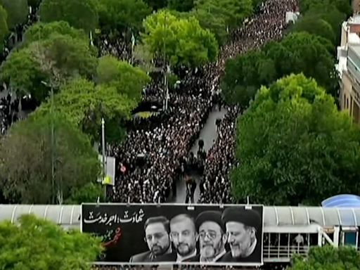
Iran president death latest: Ebrahim Raisi’s funeral procession underway as US says he had ‘blood on his hands’
White House national security spokesperson ... Raisi had “blood on his hands” over the alleged execution of thousands of Iranian anti-regime protesters...Mr Kirby said. But he added that “as ...
6 days ago
15 hours ago · Iran is a mountainous, arid, and ethnically diverse country of southwestern Asia. The heart of the Persian empire of antiquity, Iran has long played an important role in the region as an imperial power and as a factor in superpower rivalries. Modern Iranian culture owes itself in part to a renaissance in the 8th century.
People also ask
What is Tehran known for?
Why is Tehran called 'Tehran'?
Why is Tehran the capital of Iran?
Is Tehran a cosmopolitan city?
1 day ago · With a dramatic topography reflective of its proximity to the highest peak in the country, Tehrān is Iran’s gateway to the outside world. Tehrān’s image abroad was strongly influenced by the Iranian Revolution of the late 1970s.

