Search results
North Carolina Mountains. Type: region. Description: region of North Carolina in the United States. Location: North Carolina, South, United States, North America. View on OpenStreetMap. Latitude of center. 35.88° or 35° 52' 48" north. Longitude of center. -82.36° or 82° 21' 36" west.
Map of 2,697 North Carolina mountains showing elevation, prominence, popularity, and difficulty.
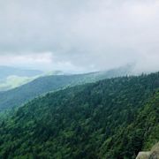
Nestled among North Carolina’s Blue Ridge and Great Smoky Mountains are small towns big on character, outdoor adventures and culinary delights. Browse trip ideas, things to do, places to stay and more from Cherokee to Asheville to Boone.
Mar 24, 2022 · Pondering a mountain escape in North Carolina? From Asheville to Great Smoky Mountain National Park, these are the best getaways in the North Carolina Mountains.
- Gwen Pratesi
- Contributor
People also ask
What is the geography of North Carolina?
Where is North Carolina located?
How big is North Carolina?
Where is Black Mountain North Carolina?
Jan 18, 2024 · Outline Map. Key Facts. North Carolina is a state in the southeastern United States. It borders Virginia to the north, the Atlantic Ocean to the east, South Carolina to the south, and Georgia and Tennessee to the west. The state covers a total area of approximately 53,819 mi 2 (139,390 km 2 ).
Mountains in North Carolina. FREE interactive map and complete list of ALL the mountains in North Carolina from the state highest point to the lowest summits of NC.
3D Topographical Map of North Carolina. The geography of North Carolina falls naturally into three divisions — the Appalachian Mountains in the west (including the Blue Ridge and Great Smoky Mountains ), the central Piedmont Plateau, and the eastern Atlantic Coastal Plain.