Search results
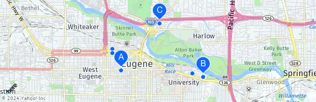
LTD Bus Station. The Downtown Eugene station is the hub of the area’s transit system. PeaceHealth Rides bikeshare pick-up sites. See back for more information about transportation options.
Eugene Map. Eugene is the second largest city in the U.S. state of Oregon and the seat of Lane County. It is located at the south end of the Willamette Valley, at the confluence of the McKenzie and Willamette rivers, about 50 miles (86 km) east of the Oregon Coast.
- Eugene, OR
Request a free Eugene, Cascades & Coast Official Visitor Guide which includes a detailed, pull-out map of Eugene-Springfield and the Eugene, Cascades & Coast region. Order online or stop by the Eugene, Cascades & Coast Visitor Center to pick up complimentary guides, maps and brochures.
Eugene is a city in Oregon at the southern end of the Willamette Valley near the confluence of the Mckenzie and Willamette rivers. It is best known for being the home of the University of Oregon. View of downtown Eugene from the top of Skinner Butte…. Map. Directions.
May 4, 2024 · Set at the southern end of the vast Willamette Valley, Eugene is a fun, vibrant and youthful city to explore that has a lot of tourist attractions. Home to plenty of parks and gorgeous green spaces, it lies not far from the confluence of the rushing McKenzie and Willamette Rivers, just west of the m.
Downtown Eugene is at the center of Eugene. It is also the center of the region between the Cascades and the Coast. Reach these close destinations through ride share and public transportation options. Distances are approximate.
People also ask
Where is Eugene Oregon located?
What is downtown Eugene?
What's new in downtown Eugene?
Is Eugene a good place to live?