Search results
PED/BI BRIDGE 1/8 Mile Hays Tree Garden Cuthberti Amphi- theater Community Garden Native Plant Nursery 250 Feet EUGENE WHILAMUT AREA KNICKERBOCKER PED/BIKE BRIDGE University of Oregon AUTZEN PED/BIKE BRIDGE Millrace x St w D St Springfield ODLAND. Title. Alton Baker Park Map. Created Date. 3/26/2009 3:03:46 PM.
Alton Baker Park. Bicycle Map - Eugene (2022 ), Springfield (2022) Golden Gardens. Kalapuya Talking Stones. North and South Amazon Trail. Owen Rose Garden. Pre’s Trail (Sendero de Pre en el Parque Alton Baker en Espanol) Skinner Butte Park. Ridgeline Trail ( Sistema de Senderos de Ridgeline en Espanol)
- Description
- University of Oregon Hatfield-Dowlin Complex Practice Field Expansion
- Oregon Football Gameday Parking
- 2018 Parks and Recreation Bond and Levy
- West Alton Baker Park
- Volunteer
- Additional Information
- Documents
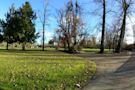
Alton Baker Park, Eugene’s largest developed park, is home to dozens of recreational features and facilities serving the City of Eugene since 1959. The park is made up of two major areas: the more developed West Alton Baker Park, and the 237-acre Whilamut Natural Area. 1. 373 acres (total owned by the City of Eugene) 2. North region 3. Harlow Neigh...
The University of Oregon is planning to build a new indoor practice field next to Autzen Stadium. Site work has begun at the Eugene Science Center parking lot. For more information from University of Oregon, visit this website.
During Oregon football home games, the three paved lots near the entrance of the park (green and yellow lots shown in map below) are used for gameday parking. The lots are managed by Reef Parking. The cost is $20 per game (credit cards only, no cash). Season passes are available at the first two home games. Parking passes can only be purchased in p...
An upgrade of existing lighting in Alton Baker Park funded by the 2018 Parks and Recreation Bondfocused on the western loop of Pre’s Trail. The lighting system utilizes energy efficient LED technology and minimizes adverse impacts to habitat and wildlife by using warmer temperature lighting. This work was completed in November 2021. As new bond pro...
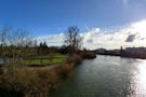
Located immediately east of the Ferry Street Bridge along the north bank of the Willamette River, West Alton Baker Park has had a long history of development, first under the jurisdiction of Lane County Parks Department, and more recently under the jurisdiction of the City of Eugene Parks and Open Space Division. The original 20-acre parcel was pur...
Help activate the power of parks by getting involved with our Volunteer Program. Learn new skills, meet great people, and improve the quality of life in Eugene by helping to care for our parks and open spaces. The Native Plant Nurseryhas unique volunteer opportunities for community members who would like to actively participate in the full cycle of...
Parks Planning: Mark Kosmos, Landscape Architect Ph: 541-682-4902PARK ENTRANCE P a t t e r s o n S l o u g ... Eugene To University of Oregon To Springfield Roads Pedestrian/Bike Bridges ... Alton.Baker.Map.2.24.22KMM
Get more information for Alton Baker Park in Eugene, OR. See reviews, map, get the address, and find directions.
- 501 Day Island Rd, Eugene, 97401, OR
- mailto:help@mapquest.com
- 5.4B
Easy • 4.5 (162) Alton Baker Park. Photos (314) Directions. Print/PDF map. Share. More. Length 3.4 miElevation gain 55 ftRoute type Loop. Experience this 3.4-mile loop trail near Eugene, Oregon. Generally considered an easy route, it takes an average of 1 h 1 min to complete.
Want to find the best trails in Alton Baker Park for an adventurous hike or a family trip? AllTrails has 6 great trails for walking and birding and more. Enjoy hand-curated trail maps, along with reviews and photos from nature lovers like you. Ready for your next hike or bike ride?

 Alton Baker Park Map - Eugene, Oregon - DOKUMEN.TIPS")