Search results
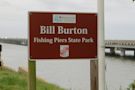
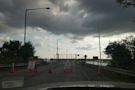
All information on the fishing piers closure is up-to-date as of April 2024. . The fishing piers at Bill Burton Fishing Pier State Park are closed in both Dorchester and Talbot Counties due to structural safety concerns. Shoreline and trail access is open on the Talbot County side of the park and the pedestrian access to the Visitor Center ...
- Fishing Crabbing - Maryland Department of Natural Resources
Bill Burton Fishing Pier State Park. Fishing and Crabbing...
- Trail Map - Maryland Department of Natural Resources
Trail Map. A map of the trails at Bill Burton Fishing Pier...
- Fishing Crabbing - Maryland Department of Natural Resources
Want to find the best trails in Bill Burton Fishing Pier State Park for an adventurous hike or a family trip? AllTrails has 1 great trails for hiking and more. Enjoy hand-curated trail maps, along with reviews and photos from nature lovers like you.
- (56)
- Maryland, United States
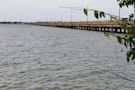
Bill Burton Fishing Pier State Park is a popular fishing destination and state park in Maryland. Located on the Choptank River, the park offers stunning views of the Chesapeake Bay. Anglers can enjoy various fishing opportunities and catch a variety of fish species.
Bill Burton Fishing Pier State Park. Photos (81) Directions. Print/PDF map. Share. More. Length 1.1 miElevation gain 13 ftRoute type Loop. Explore this 1.1-mile loop trail near Trappe, Maryland. Generally considered an easy route, it takes an average of 19 min to complete.
- (56)
- Trappe, Maryland, United States
Coordinates: 38°35′26″N 76°02′40″W. Bill Burton Fishing Pier State Park (formerly the Choptank River Fishing Pier) is a public recreation area on the Choptank River in Trappe, Maryland. The state park preserves portions of the former Choptank River Bridge as a pier, and includes 25 acres (10 ha) of land upriver from the pier in Talbot County. [2]
People also ask
Where is Bill Burton fishing pier State Park?
Does Bill Burton fishing pier have a fishing pier?
Is Bill Burton fishing pier open in Dorchester & Talbot County?
Where is the fishing pier in Trappe MD?
As of September 2022, the fishing piers remain closed to the public due to structural issues. The trails and picnic areas are still open. Parks. Bill Burton Fishing Piers State Park consists of two large fishing piers and waterfront areas overlooking the Choptank River near Cambridge, MD.