Search results
Discover more placesNear Outer Banks
Refine results for Beaches
Map of Outer Banks, NC. This map of the Outer Banks shows the fragile barrier islands stretching over 100 miles along the coast of North Carolina. If you have visited the Outer Banks during the summer season, then you’re well aware that it is a hot vacation spot, and has been for decades.
- Things to Do
With so many things to do at the Outer Banks, it’s a hard to...
- Places to Stay
Browse the endless types of accommodations the Outer Banks...
- Things to Do
- Kitty Hawk
- Nags Head
- Kill Devil Hills
- Southern Shores
- Duck Beach
- Corolla Beach
- Ocracoke
- Hatteras Island
- Roanoke Island
- Avon Beach
In the 1900s, the Wright Brothers famously carried out experiments in flight right in our very own Outer Banks. Kitty Hawk’s name has spread far and wide in unison with the beginnings of aviation. The architecture of the area is centered on historic beach homes, offering a quaint, small-town charm. As it rests on such a wide section of the Outer Ba...
This stretch of sandy coastline is home to a vibrant community and a wealth of natural beauty. Nags Head is known for having the longest public pier in North Carolina, a charming wooden structure that provides the perfect sunset stroll. There is an abundance of beachside amenities here, making it an Outer Banks vacation hotspot. Nags Head is known ...
Kill Devil Hills is just the busy, bustling beach town that you may expect. It’s home to all of the usual beachfront shops, selling trinkets to tourists with just the right amount of kitsch. There are many hotels and resorts in the area for a luxury stay. There are eateries and bars galore, so take your pick for delicious oceanfront dining and drin...
Here, you will find stunning, sweeping views across the Atlantic Ocean making it one of the best Outer Banks beaches. There is little commercial development in this area, resulting in a more undisturbed beach-going experience. Southern Shores is almost entirely residential, and it has an overtone of secluded charm. The shores are quiet and calm – i...
If you have a furry friend in tow this vacation, Duck Beach is one of the best Outer Banks beaches for you. Not much of a resort town, you will probably need to rent a cozy beach cottage, or possibly extravagant beach estate for your stay. Duck is also home to the originalDuck Donuts. We recommend a breakfast stop here at least once while you’re in...
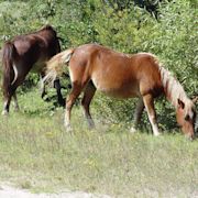
Corolla is a special beach town in the Outer Banks. Its name means the collection of petals on a flower, and its atmosphere is just as delightful. Corolla’s main draw is the population of wild horses which roam the coastline here. Be sure to appreciate the beauty of the Spanish Mustangs from a safe distance as they have been living free for centuri...
Located on the Cape Hatteras National Seashoreat the far southern end of the banks, Ocracoke is accessible only by boat. This adds to the mystique and seclusion of the space. It’s a quaint and historic town with calm and quiet beaches. Hop aboard a ferry and make your way to this magical haven. Keep your eyes out for plenty of native wildlife here ...
If you’re hoping to fish on your Outer Banks excursion, then you’ll be hooked on Hatteras Island. It’s home to several small villages and long stretches of shoreline. It’s an often uncrowded and charming beach break to take. Over the centuries it has been the site of over 600 shipwrecks as the sandbars here can shift due to rough waves and currents...
Roanoke Island is shrouded in history and mystery as it was the site of the first English colony in the New World. It’s also the site where the 120 settlers of this colony simply vanished. There are many theories of theLost Colony,as it’s now known, but to this day it remains a legend of intrigue and uncertainty. It’s also famously the birthplace o...
Avon Beach has miles and miles of undeveloped beaches. It is a popular spot for surfing, fishing, and watersports and is often considered the best place to surf in the Outer Banks. Besides surfing, you’ll find a fishing pier and a water tower that reads “Kinnakeet,” the former name of Avon. Kinnakeet is an Algonquin word meaning “that which is mixe...
- Nags Head. The name Nags Head, supposedly related to pirate activities, may not inspire much of a pleasant mental picture; however, cast those worries aside.
- Kitty Hawk Beach. If you are coming to the Outer Banks from the north, the beach at Kitty Hawk will be the first one you come to after you cross Currituck Sound.
- Avon Beach. The beach at Avon is a low-key affair and flies below most people's radar. Wide, long, and uncrowded, this beach is primarily the domain of families renting one of the numerous beach houses.
- Ocracoke Island. One of the more unique places to hit the beach is Ocracoke Island. It takes a bit of work to get here. Two routes are available: a long drive down the entire Outer Banks then a ferry ride from Hatteras in the north, or a twisty route from Moorehead City to Cedar Island in the south.
People also ask
How many places are in Outer Banks NC?
What are the best beaches in the Outer Banks?
Is the Outer Banks a big beach?
What is on a map of the Outer Banks?
Outer Banks Maps. Choice from a collection of Outer Banks maps below, Map of islands and towns, driving directions, mileage chart, map of landmarks and historic sites, lighthouses, and area golf courses.
These places are best for beaches in Outer Banks: Ocracoke Lifeguarded Beach; Cape Hatteras National Seashore; Currituck Beach; Pea Island National Wildlife Refuge; Carova Beach; See more beaches in Outer Banks on Tripadvisor
- What are the best places for beaches in Outer Banks?These places are best for beaches in Outer Banks:Ocracoke Lifeguarded BeachCape Hatteras National SeashoreCurrituck BeachPea Island National Wildli...
- Which places provide the best beaches in Outer Banks for kids and families?These are the best places for kid-friendly beaches in Outer Banks:Ocracoke Lifeguarded BeachCape Hatteras National SeashoreCurrituck BeachPea Islan...
- Which places provide the best beaches in Outer Banks for couples?These are the best places for couples seeking beaches in Outer Banks:Ocracoke Lifeguarded BeachCape Hatteras National SeashoreCurrituck BeachPea Is...
- Which places provide the best beaches in Outer Banks for groups?These are the best places for groups seeking beaches in Outer Banks:Cape Hatteras National SeashoreCurrituck BeachPea Island National Wildlife Refu...
- Which places provide the best beaches in Outer Banks for travelers on a budget?These are the best places for budget-friendly beaches in Outer Banks:Ocracoke Lifeguarded BeachCape Hatteras National SeashoreCurrituck BeachPea Is...
- Which places provide the most romantic beaches in Outer Banks?These are the most romantic places for beaches in Outer Banks:Ocracoke Lifeguarded BeachCape Hatteras National SeashoreCurrituck BeachSee more roma...
- Which places provide the best hidden gems for beaches in Outer Banks?These are the best hidden gems for beaches in Outer Banks:Carova BeachOcracoke BeachOcracoke Lifeguard BeachSee more hidden gem beaches in Outer Ba...
Feb 29, 2024 · Our guide starts with the embedded map of Outer Banks NC and is followed by indexes of the featured OBX towns and protected lands. Here’s how we’ve organized this guide: NC Tripping’s Map of Outer Banks NC (via Google Maps) Outer Banks NC Map Attractions Listed. Currituck County (Corolla and More) Dare County. Avon.
Jun 15, 2023 · The Outer Banks are a set of barrier islands in the northeastern part of North Carolina, just South of the Virginia border. The islands easily accessible by car via major interstate highways: About 1.5 hours south from Norfolk, Virginia, via US-158. About 3.5 hours west from Raleigh, NC, via Interstate 40.