Search results
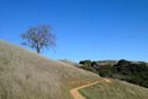
The 3,436-acre preserve is one of Midpen's richest in wildlife and ecosystem diversity. Monte Bello Preserve is surrounded by other open space preserves and parks, which makes trip options nearly limitless. Black Mountain offers visitors incredible views of Santa Clara Valley and over to Mt. Hamilton. Highlights.
Monte Bello Preserve Loop is a moderate to difficult loop through Monte Bello Open Space Preserve and a portion of Rancho San Antonio Open Space Preserve as it summits Black Mountain. The well-maintained route offers beautiful rolling hills, spectacular views from Santa Cruz to the Bay, and a number of wildlife and wildflower viewing opportunities, especially in late March and early April ...
- (944)
- Los Altos Hills, California, United States
People also ask
What is Monte Bello open space preserve?
Is Monte Bello a good place to visit?
What is Monte Bello Ridge known for?
Why is Monte Bello Ridge called Mountain View?
According to AllTrails.com, there are 5 biking trails in Monte Bello Open Space Preserve and the most popular is Stevens Creek Nature Trail to White Oak Trail Loop with an average 4.6 star rating from 416 community reviews. Hours: half an hour before sunrise to half an hour after sunset.
- (3.6K)
- California, United States
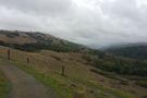
This loop starts at the Monte Bello Open Space Preserve parking lot and takes the shortest path to Black Mountain, with nice views of the area on Bella Vista Trail. The return path goes down to Stevens Creek and back up to the parking lot with Canyon Trail. Variations are possible by branching off to Stevens Creek Nature Trail and others from there (Skid Rd Trail, White Oak Trail).
- (782)
- Los Altos Hills, California, United States
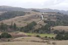
Nov 23, 2020 · Description. This is an amazing 2-hour hike in the Monte Bello Open Space Preserve that has a beautiful creek and scenic views. This hike is best done in the late fall, winter, and spring so that the creek is running and the hills are green. Starting at the preserve parking lot, the first half of the hike is predominantly downhill.
- (4)
Ridge Trail, Peters Creek & Canyon Trail loop — Skyline Ridge Open Space Preserve. 07:03. 24.1 km. 3.4 km/h. 670 m. 670 m. Expert. 6. Expert Hiking Tour.
Monte Bello Open Space mountain bike trail map. 32 trails on an interactive map of the trail network.