Search results
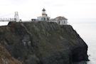
A secret jewel of the Bay Area, the Point Bonita Lighthouse, built in 1855, was the third lighthouse built on the West Coast and helped shepherd ships through the treacherous Golden Gate straits. Today, the lighthouse is still active and is maintained by the U.S. Coast Guard.
- Safety
- Restrooms
- Trail Etiquette
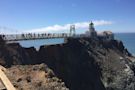
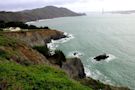
The half-mile trail to the lighthouse is steep and uneven, with loose gravel. Wheelchairs are not advised (assistance may be needed in descending and climbing).Stay on the established trail. Observe warning signs and railings—these exist for your safety. Cliffs along the point can be unstable and hazardous.Dress in layers and be prepared for varying weather conditions. Sunny days along the coast can turn windy, foggy, and cold very fast.Please be mindful of poison oak along trails. Even a slight brush of the plant’s oils can cause a serious reaction. Staying on trails and learning to identify poison oak with its three leaves will...An accessible restroom can be found at the Point Bonita parking area. There are no restrooms at the Point Bonita Lighthouse.
Please remain on the established trail. Off-trail travel harms plants and causes erosion. Keep your food within arm's reach at all times and do not feed the wildlife. Carry out all trash and food waste (fruit peels, shells, etc.). No Pets and No Bikes allowed anywhere on the trail (including the paved path that leads to the tunnel). Pushing / walki...
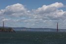
Easy • 4.6 (623) Golden Gate National Recreation Area. Photos (1,414) Directions. Print/PDF map. Share. More. Length 1.0 miElevation gain 203 ftRoute type Out & back. Check out this 1.0-mile out-and-back trail near Sausalito, California. Generally considered an easy route, it takes an average of 30 min to complete.
- (623)
- Sausalito, California, United States
Point Bonita Lighthouse. Yes, this lighthouse at the southwest tip of the Marin Headlands is still active and maintained by the U.S. Coast Guard. Getting there is a challenge, parking is limited and the 0.5-mile walk is steep and precarious. This spot, at the “world’s end,” is ruggedly beautiful.
External links. Point Bonita Lighthouse. Coordinates: 37.815614°N 122.529578°W. Point Bonita Lighthouse is a lighthouse located at Point Bonita at the San Francisco Bay entrance in the Marin Headlands near Sausalito, California. Point Bonita was the last staffed lighthouse on the California coast.
- 1855 (first)
- 33 ft (10 m)
- brick and cement building
People also ask
Where is Point Bonita Lighthouse?
Does Point Bonita Lighthouse have cell service?
Is the Point Bonita Lighthouse still active?
How do I get to Point Bonita Lighthouse?
Point Bonita Lighthouse, California Lighthouses, photographs, pictures, history, location, visitor information, maps, description, hotels, Lighthousefriends.com.
Apr 5, 2024 · Golden Gate National Recreation Area. Point Bonita Lighthouse at sunset. Mel Mashman. Quick Facts. Amenities. 2 listed. NOTE: There is limited cell service at the lighthouse. To use the app with partial functionality on-site, download the data to your phone ahead of time.