Search results
Sep 19, 2023 · Map of Tahoma National Cemetery Address. The Tahoma National Cemetery is located at: 18600 SE 240th Street Kent, WA 98042. Visitors can find the administrative building on the right as they enter Veterans Memorial Dr. If you have questions about this national cemetery and map, please contact 425-413-9614. Map
- Tahoma National Cemetery - National Cemetery Administration
Tahoma National Cemetery is ¼ mile on left. SCHEDULE A...
- Tahoma National Cemetery - Locations - Veterans Affairs
Locations. Tahoma National Cemetery. | View the Web Site....
- Tahoma National Cemetery - National Cemetery Administration
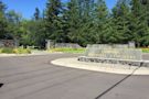
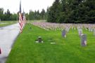
Map. See all cemetery photos. About. Get directions 18600 Southeast 240th Street. Kent, Washington 98042-4868 United States. Coordinates: 47.38722, -122.09354. www.cem.va.gov/CEM/cems/nchp/tahoma.asp. (425) 413-9614. Cemetery ID: 109448. Members have Contributed. 74,472 Memorials. 99% photographed. 13% with gps. About these numbers. Photos.
Coordinates: 47°23′31″N 122°05′35″W. Tahoma National Cemetery is a United States National Cemetery in unincorporated King County, Washington. It encompasses 158.3 acres (64.1 ha), and as of the end of 2019, had over 60,000 interments, compared to the end of 2008 with 23,479 interments, and 15,924 interments in 2005.
- 1993
- United States
- 158.3 acres (64.1 ha)
- King County, Washington
Washington. Puget Sound. King County. Tahoma National Cemetery is a United States National Cemetery in unincorporated King County, Washington. It encompasses 158.3 acres, and as of the end of 2019, had over 60,000 interments, compared to the end of 2008 with 23,479 interments, and 15,924 interments in 2005. cem.va.gov. +1 425 413 9614. Wikipedia.
Tahoma National Cemetery Keywords: Tahoma National Cemetery, map, cemetery map Created Date: 6/27/2016 3:37:26 PM ...
People also ask
Where is Tahoma National Cemetery?
How many people are buried in the Tahoma National Cemetery?
Does Tahoma National Cemetery have a veterans service organization?
How does the Public Information Center work at Tahoma National Cemetery?
![Home Page [www.olypen.com]](https://images.search.yahoo.com/search/images?p=tahoma+national+cemetery+map&ei=UTF-8&_tsrc=apple&age=1w&th=107.9&tw=81.2&imgurl=http%3A%2F%2Fwww.olypen.com%2Fhgreid%2Fimages%2FTacoma%2520National%2520Cemetery%2FMap%2520of%2520Tahoma%2520National%2520Cemetery%2520-a.jpg&rurl=http%3A%2F%2Fwww.olypen.com%2Fhgreid%2F&size=69KB&name=Home+Page+%5Bwww.olypen.com%5D&oid=1&h=842&w=633&turl=https%3A%2F%2Ftse1.mm.bing.net%2Fth%3Fid%3DOIP.h4b6jaosOwqPnZcxeOsUjwHaJ2%26pid%3DApi%26rs%3D1%26c%3D1%26qlt%3D95%26w%3D81%26h%3D107&tt=Home+Page+%5Bwww.olypen.com%5D&sigr=7HUOTeiI2uPg&sigit=93DMfY9ObvbP&sigi=21c3p8PW0.Zv&sign=qr9FS2oF1MQ4&sigt=qr9FS2oF1MQ4 "Home Page [www.olypen.com]")