Search results
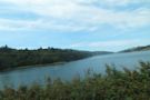
The Sawyer Camp segment of the Crystal Springs Regional Trail extends from Hillcrest Blvd. on the north to Crystal Springs Road on the south, and is probably the best known length of trail in San Mateo County. More people know it and use it than all the other trails in the County Park System.
- Sawyer Camp Trail Self-Guided Tour | County of San Mateo, CA
Health (San Mateo County Health) Housing (Department of...
- Sawyer Camp Trail Self Guided Tour Sheet - San Mateo County ...
Trail. Junipero Serra. Sawyer Camp Trail Self-guided Tour....
- Sawyer Camp Trail Self-Guided Tour | County of San Mateo, CA
Sawyer Camp Trail. Get to know this 11.6-mile out-and-back trail near San Mateo, California. Generally considered an easy route, it takes an average of 3 h 46 min to complete. This is a very popular area for birding, road biking, and running, so you'll likely encounter other people while exploring.
- (2.1K)
- San Mateo, California, United States
People also ask
Where is Sawyer Camp in San Mateo County?
What is Sawyer Camp Trail?
Is Sawyer Camp Trail worth it?
Is Sawyer Camp a good place to walk?
Sawyer Camp Trail is one of my favorite trails on the Peninsula. An easy, paved walk on gently sloping hills, the trail is a perfect fit for just about anyone from cyclists and runners to moms with little ones or even strollers.
- (148)
- Attraction
Sawyer Camp Trail is a 6 mile trail in San Mateo County near the San Mateo Highlands. The path is paved in asphalt and is used by walkers, joggers and cyclists. Dogs are not permitted on the trail.
- (434)
- 37.530871
- Crystal Springs Rd & Skyline Blvd San Mateo, CA 94401
- 122.364365
Sawyer Camp Trail. Easy • 4.6 (2045) San Francisco State Fish and Game Refuge. Photos (1,892) Directions. Print/PDF map. Share. More. Length 18.7 kmElevation gain 139 mRoute type Out-and-back. Get to know this 18.7-km out-and-back trail near San Mateo, California. Generally considered an easy route, it takes an average of 3 h 46 min to complete.