Search results
Mar 26, 2024 · The Francis Scott Key Bridge was opened in 1977 and carried more than 12.4 million vehicles last year. The bridge was one of the three major ways to cross the Patapsco River and formed part of ...
- Weiyi Cai
Categories: truss bridge, toll bridge and transportation. Location: Baltimore County, Central Maryland, Maryland, Mid-Atlantic, United States, North America. View on OpenStreetMap. Latitude. 39.21761° or 39° 13' 3" north. Longitude. -76.52719° or 76° 31' 38" west.
Mar 26, 2024 · Baltimore's Francis Scott Key Bridge opened to traffic on March 23, 1977, and was a crucial thoroughfare for the region, carrying some 11.3 million vehicles per year.
- kerry.breen@paramount.com
- Paula Cohen,Kerry Breen
- 2 min
People also ask
What is the Francis Scott Key Bridge?
What happened to the Francis Scott Key Bridge in Baltimore?
Is the Francis Scott Key Bridge collapse a 'national economic catastrophe'?
When did a container ship hit the Francis Scott Key Bridge?
The Francis Scott Key Bridge was a steel arch-shaped continuous truss bridge, the second-longest in the United States and third-longest in the world. Opened in 1977, the 1.6-mile (2.6 km; 1.4 nmi) bridge ran northeast from Hawkins Point, Baltimore , to Sollers Point in Dundalk in Baltimore County, Maryland .
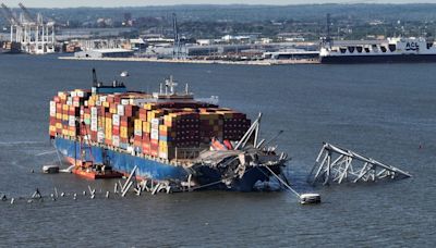
Mar 26, 2024 · The cargo ship Dali started moving at 12:51 a.m. Tuesday and within a half hour struck the Francis Scott Key Bridge as it made its way out of the Port of Baltimore on the Patapsco River.
Mar 26, 2024 · Baltimore's Francis Scott Key Bridge collapses after being struck by cargo ship. This article is more than 1 month old How Baltimore’s Key Bridge collapsed – a visual guide
Mar 26, 2024 · The cargo ship Dali started moving at 12:51 a.m. Tuesday and within a half hour struck the Francis Scott Key Bridge as it made its way out of the Port of Baltimore on the Patapsco River.

