Search results
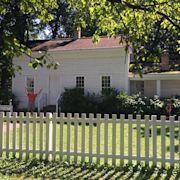
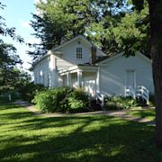
4901 S Minnehaha Park Drive. Minneapolis, MN 55417. Get Directions. Contact. Phone: 612-722-2220. Email : info@minneapolisparks.org. Hours of Operation. TEMPORARILY CLOSED. Plan Your Route. Bus, bike, drive, or walk. John H. Stevens House. Part of: Minnehaha Regional Park. View Photo Gallery. Features & Amenities. Historical Site Details. History.
- Introduction
- History
- Contact Information and Directions
Inside the house, visitors can can experience the rich history of the house through displays that show the Stevens family and other early Minnesotan families who occupied the house. The Longfellow Houseand Stevens House co-sponsor 90-minute historic nature walks through the park.
Originally located near St. Anthony Falls, the house was home to Col. John H. Stevens and is believed to be the first home built west of the Mississippi in Minneapolis. Stevens had permission in 1850 to occupy the site, which was part of the Fort Snelling military reservation, in exchange for providing ferry service. The Dakota Indians sometimes ca...
Call 612-722-2220 or visit Minneapolis Park & Recreation Boardfor more details.4901 Minnehaha Avenue South, Minneapolis, MN (inside Minnehaha Park)John Harrington Stevens House, 4901 Minnehaha Ave, Minneapolis, MN - MapQuest. Closed today. (612) 722-2220. Website. More. Directions. Advertisement. 4901 Minnehaha Ave. Minneapolis, MN 55417. Closed today. Hours. Sun 10:00 AM - 4:00 PM. (612) 722-2220. http://www.johnhstevenshouse.org. Also at this address. Own this business? Claim it.
- 4901 Minnehaha Ave, Minneapolis, 55417, MN
- (612) 722-2220
Oct 16, 2008 · Marker is at or near this postal address: 4901 South Minnehaha Park Drive/Avenue, Minneapolis MN 55417, United States of America.
Jun 22, 2021 · John H. Stevens had just served in the Mexican-American war in 1848 when he came to Minnesota, then still a territory, for health reasons. The west bank of the Mississippi River, now downtown ...
About. Minnehaha District Map. Minnehaha Falls, 1895. Stevens House, 1905. Boundaries: Generally bounded by Nawadaha Boulevard, 39th Avenue South, 49th Street, Hiawatha Avenue, Minnehaha Avenue, Minnehaha Creek and the Mississippi River. Neighborhood: Hiawatha. Date of Local Designation: 1986. Date of National Designation: 1969.
People also ask
What happened to the Stevens House in Minneapolis?
Who owns the John H Stevens House?
What is the Longfellow House and Stevens House?
How many times has the Minnehaha house been relocated?
Apr 29, 2011 · Location. 44° 59.05′ N, 93° 15.825′ W. Marker is in Minneapolis, Minnesota, in Hennepin County. It is in Central Minneapolis. Marker is on West River Parkway, 0.4 miles west of Portland Avenue South, on the right when traveling west.