Search results
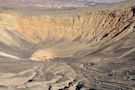
Jan 3, 2022 · Ubehebe Crater is a large volcanic crater 600 feet deep and half a mile across. We often hear mistakenly that "Ubehebe" means "big basket," but the Paiute name Ubehebe was first applied to the 5,678 ft. Ubehebe Peak, 24 miles southwest of the crater.
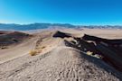
Coordinates: 37°0′35″N 117°27′1″W. Ubehebe Crater - Panoramic view. Ubehebe Crater ( / jubiˈhiːbi / yoo-bee-HEE-bee) is a large volcanic crater of the Ubehebe Craters volcanic field in the northern half of Death Valley, in Death Valley National Park, California, United States. Geography.
May 2, 2023 · Furnace Creek Visitor Center to Ubehebe Crater (Google Map) From the Furnace Creek Visitor Center, you’ll drive northwest 56.3 miles traversing CA-190W and Scotty’s Castle Road. Make a right when you get to Scotty’s Castle Road. Once you reach Ubehebe Crater Road, stay left, and drive 5.3 miles to the parking area.
Map Legend. Ubehebe (pronounced you-bee-HEE-bee) Craters, located about 225 km (140 mi) northwest of Las Vegas, NV, and 88 km (55 mi) southeast of Bishop, CA, in Death Valley National Park, consists of thirteen overlapping volcanic craters. The largest crater is about 800 m (0.5 mi) wide and 250 m (800 ft) deep. Summary.
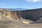
Apr 5, 2024 · Location: Death Valley National Park. Significance: Maar Volcano. Amenities. 4 listed. The earth shook, roared, and exploded. When the debris settled, a new crater appeared. Ubehebe Crater in northern Death Valley National Park is an excellent place to explore the power of maar (explosion pit) volcanoes.
Death Valley Map. In: National Parks. Ubehebe Crater, pronounced "YOU-BE-HE-BE", is an otherworldy crater in Death Valley created not by a meteor strike but volcanic activity.
People also ask
What is the Ubehebe Crater in Death Valley National Park?
Where is Ubehebe Crater?
What happened at Ubehebe Crater?
How do I get to little Ubehebe Crater?
Jun 7, 2017 · Explore Death Valley's own maars volcano! Trail description, photos, GPS map, and directions to Ubehebe Crater in Death Valley National Park, California hikespeak


")