Search results
Route 66 Monument. Tucumcari, New Mexico. Tucumcari is the quintessential Route 66 town, with its procession of snapshot-ready motel signs and buildings from a vintage era of highway travel. There's the famous neon of the Blue Swallow Motel, the arrowhead motel sign of the Apache, the perky Mexican hat atop the La Cita restaurant, and the ...
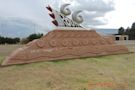
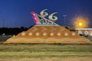
When you’re entering Tucumcari from the west, you’ll pass this sculpture commemorating Route 66. It’s a fun piece and a great opportunity for a photo. Read more
- (128)
- Attraction
May 29, 2023 · The Route 66 Monument in Tucumcari, New Mexico was dedicated in 1997. While it wasn’t in place when Route 66 was active, the monument celebrates the Mother Road’s past, present, and future and Tucumcari’s place within.
Apr 25, 2024 · The Route 66 Monument in Tucumcari, New Mexico was dedicated in 1997 as a tribute to the Mother Road’s past, present, and future and Tucumcari’s place within.
- What to Do, Places to See
- Tucumcari, Its Attractions
- A Driving Tour Through Tucumcari Along Route 66
- The Old Alignment of Route 66 Near Tucumcari
- National and State Parks
The Gateway to New Mexico
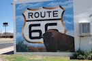
Tucumcari is the "Heart of the Mother Road" and has some classic Route 66 sights (some listed in the National Register of Historic Places): the Blue Swallow Motel, the Cactus Motor Lodge and the Odeon Theater and of course, the Route 66 segment itself. Other must sees are the Mesalands Dinosaur Museum and the Teepee Curio Shop. Historic Route 66 crosses the center of the town as Route 66 Boulevard (formerly Ganyell Ave. or Tucumcari Blvd.), along it you will find many old service stations, di...
Rock Island-Southern Pacific Train Depot
N 2nd St. and W Railroad Ave., Tucumcari This landmark was built in 1926 and restored in 2001. It was built in Spanish Mission style, a long depot for freight plus the passenger area. It served the Rock Island Railway and Southern Pacific Railway. Open to the public. See its Street View . Not far from the railway station, once stood the old Tucumcari Motel, at 301 E. Smith Ave. It has been demolished, but its rusty old sign still stands (Street View).
Route 66 attractions
This is a 6 mile drive east to west through Tucumcari, from Exit 335 to Exit 329 of I-40 (Map with directions). As you enter Tucumcari from the east, on your right is a sign of a Whiting Brothers gas station:
Whiting Brothers Sign
4001 E Tucumcari Blvd. On the north side of US66, just past the Super 8 Motel. It is pictured below. Four Whiting brothers (Arthur, Earnest, Eddie and Ralph) founded the company in 1926 and saw it grow to over 100 filling stations plus motels and truck stops from California to Texas. Many of them were located along Route 66 where you can still see the remains of those that were abandoned. By the mid-1980s the company folded and sold off or closed the service stations.
Two historic Markers
Further ahead, to your right you will see two historic markers, one tells about Tucumcari Mountain -you can see it to your left; which "has long been a landmark for travelers along the Canadian River. Pedro Vial mentioned it in 1793, while opening a trail between Santa Fe and St. Louis. In order to find the best route from Arkansas to California, Capt. Randolph B. Marcy led an expedition past here in 1849". The other marker is about the town of Tucumcari: "This area was troubled by both Coman...
The road was originally aligned along the "Ozark Trail", a highway system that was promoted and created by private organizatioins, counties and states in the 1915s. It predated the Federal highway system that appeared in the mid 1920s. Initially it was a dirt road but it was completely paved by 1933.
Las Conchas Lake State Park
Conchas means shells in Spanish. The park is 32 miles northwest of Tucumcari along NM 104 (Map with directions). Contact: Website, (575) 868-2270. Ideal place for boating, fishing and swimming. Hiking and wildlife watching near the lake too. There are campsites and parking for RVs
Ute Lake State Park
27 miles northeast of Tucumcari via US-54 to Logan, NM and then NM-540 to the lake. (Map with directions). Contact: 1800 540 Loop Logan, NM, Website, (575) 487-2284. The reservoir on the Canadian River is 13 miles long and offers many options for water sports: fishing, boating, swimming. There are campgrounds and RV facilities too.
Use our attraction recommendation and maps to plan your next road trip. Visit reports, news, maps, directions and info on Route 66 Monument in Tucumcari, New Mexico.
People also ask
Is Tucumcari a 'gateway to New Mexico'?
Where to stay on Route 66 in Tucumcari?
Where is Route 66 in Montoya nm?
What to do on Route 66?
Route 66 Monument, Tucumcari: See 128 reviews, articles, and 60 photos of Route 66 Monument, ranked No.7 on Tripadvisor among 17 attractions in Tucumcari.


 - 2022 Lohnt es sich? (Mit fotos)")

 - 2020 All You Need to Know Before You Go ...")
: Top Tips Before You Go with 26 ...")