Search results
Allegheny Reservoir (PA, NY) nautical chart on depth map. Coordinates: 41.9409, -78.9329. Free marine navigation, important information about the hydrography of Allegheny Reservoir, Kinzua Dam Lake.
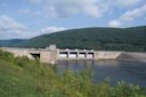
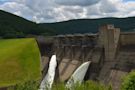
West of Bradford on Route 59, this important flood control dam has created a vast waterway known as the Allegheny Reservoir. Completed in 1965 by the US Army Corps of Engineers, the 25-Mile elongated lake fills nearly 100 miles of forested shoreline.
Cycle through all of our available maps for Kinzua. We update this regularly to make sure that the most recent maps are available for all to use! Also included here are links to PDFs...
Type: Dam. Description: dam on the Allegheny River in Warren County, Pennsylvania. Category: gravity dam. Location: Mead Township, Warren County, Pennsylvania, Mid-Atlantic, United States, North America. View on OpenStreetMap.
Kinzua Point Information Center is one of the places where visitors can look out over the reservoir from the Kinzua Dam. Longhouse National Scenic Byway has several locations where visitors will see views of the reservoir.
Allegheny Reservoir fishing map, with HD depth contours, AIS, Fishing spots, marine navigation, free interactive map & Chart plotter features.
People also ask
Where can I find information about Kinzua Dam & Allegheny Reservoir?
Where is the Kinzua Dam located?
Who owns the Kinzua Dam in New York?
Where is Allegheny Reservoir located?
Allegheny Reservoir And Kinzua Dam. 1205 Kinzua Rd. Warren, PA 16365. Phone: 814-726-0661. Region: Pennsylvania Wilds. The Allegheny Reservoir, a 12,000 acre impoundment, spans the border between Pennsylvania and New York. In Pennsylvania, the reservoir is completely surrounded by the Allegheny National Forest.