Search results
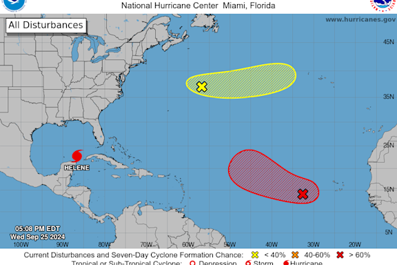
1 day ago · Satellite | Buoys | Grids | Storm Archive. ...HELENE JUST OFFSHORE THE NORTHEASTERN COAST OF THE YUCATAN PENINSULA, CLOSE TO HURRICANE STRENGTH... 7:00 AM CDT Wed Sep 25. Location: 21.1°N 86.2°W. Moving: NW at 9 mph.
- Tropical Weather Outlook
Tropical Weather Outlook. NWS National Hurricane Center...
- Central Pacific
Central Pacific - National Hurricane Center
- Satellite Imagery
Blank Tracking Maps ... NCAR-RAP Real Time Weather Data...
- Tropical Cyclone Products
Blank Tracking Maps ... Tropical Weather Discussion 0405 UTC...
- Eastern Pacific
Eastern Pacific - National Hurricane Center
- Hurricanes in History
The periodical Monthly Weather Review - articles used...
- Atlantic
Atlantic - National Hurricane Center
- Tropical Cyclone Advisories
Tropical Weather Outlooks; Marine Products; Audio/Podcasts;...
- Tropical Weather Outlook
Searches related to national weather hurricane tracking
1 day ago · Atlantic - Caribbean Sea - Gulf of Mexico. Tropical Weather Outlook (en Español) 800 PM EDT Sun Sep 22 2024. Tropical Weather Discussion. 0005 UTC Mon Sep 23 2024. There are no tropical cyclones in the Atlantic at this time.
Tropical Weather Outlook. NWS National Hurricane Center Miami FL. 800 AM EDT Wed Sep 25 2024. For the North Atlantic...Caribbean Sea and the Gulf of Mexico: Active Systems: The National Hurricane Center is issuing advisories on Tropical. Storm Helene, located over the northwestern Caribbean Sea. 1. Eastern and Central Tropical Atlantic (AL98):
The live hurricane tracker allows users to see the paths of previous hurricanes on this season’s hurricane map, as well as interact with the current hurricane tracker satellite imagery while accessing National Hurricane Center data and information.
3 days ago · One-stop event page for #Helene Posted September 24, 2024 NEWS RELEASE ALERT: Communities need to prepare for catastrophic, life-threatening inland flooding from #Helene, even well after landfall NOAA's National Weather Service wants you to have the latest, most accurate information on Hurricane Helene to keep you informed and s
Interactive world weather map. Track hurricanes, cyclones, storms. View LIVE satellite images, rain radar, forecast maps of wind, temperature for your location.


