Search results
Most Recent Earthquakes Near California
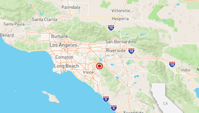
earthquake.usgs.govMagnitudeLocationTimeM4.066 hours agoM3.091 day agoM4.372 days agoM3.033 days agoM4.34 days agoM3.934 days agoM3.86 days agoM4.126 days agoEarthquakes are shown as circles sized by magnitude (red, < 1 hour; blue, < 1 day, yellow, < 1 week). Click or tap on a circle to view more details about an earthquake, such as location, date/time, magnitude, and links to more information about the quake. Local time is the time of the earthquake in your computer's time zone.
Jul 6, 2019 · A pair of large earthquakes hit Southern California over the course of two days. On Thursday, a 6.4 magnitude earthquake struck the area. The next day, a 7.1 earthquake rocked Southern...
If the application does not load, try our legacy Latest Earthquakes application. USGS Magnitude 2.5+ Earthquakes, Past Day 32 earthquakes. Only List Earthquakes Shown on Map . Magnitude. Format. Newest First. Sort. 2.5. 6 km S of Volcano, Hawaii. 2024-05-06 15:43:51 (UTC-07:00) 1.1 km . 3.0 ...
Recent Earthquakes in the Southern California Region. Use the map below to explore recent earthquake activity. This map shows the earthquake feed from the USGS for all earthquakes in the last 7 days with the network codes of CI, NC, or NN, or between the latitude coordinates 32 and 42 and the longitude coordinates -126 and -114.
Dec 21, 2022 · RIO DELL, Calif., Dec 20 (Reuters) - A powerful magnitude 6.4 earthquake jolted the extreme northern coast of California before dawn on Tuesday, crumpling homes and roads, rupturing utility...
Load M2.5+, past week Load all, past day Load all, past week (warning, slow)
Dec 21, 2022 · A 6.4 magnitude earthquake impacted Northern California's Eureka area early Tuesday, according to the US Geological Survey, leaving thousands without power. Follow the latest news here.


