Search results
Tropical Storm Debby was a tropical cyclone that caused extensive flooding in North Florida and Central Florida during late June 2012. The fourth tropical cyclone and named storm of the 2012 Atlantic hurricane season, Debby developed from a trough of low pressure in the central Gulf of Mexico on June 23. At the time, Debby was the earliest ...
The “best track” chart of Debby’s path is given in Fig. 1, with the wind and pressure histories shown in Figs. 2 and 3, respectively. The best track positions and intensities are listed in Table 11.
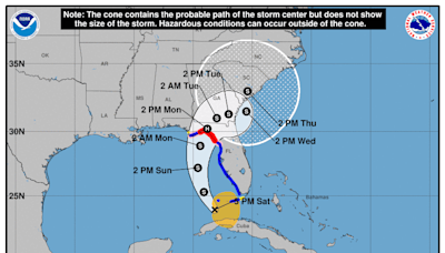
4 days ago · Historical data indicate that the entire 5-day path of the center of the tropical cyclone will remain within the cone about 60-70% of the time. To form the cone, a set of imaginary circles are placed along the forecast track at the 12, 24, 36, 48, 72, 96, and 120 h positions, where the size of each circle is set so that it encloses 67% of the ...
1 day ago · Tropical storm-force winds extended outward up to 205 miles east of the center, the center added. Debby slammed into the Big Bend coast, where the Florida panhandle meets the peninsula, near ...
Tropical Storm Debby - June 22-27, 2012. An elongated area of low pressure formed in the western Caribbean Sea in mid-June, under the base of the upper. level trough which spawned Tropical Storm Chris on the 17th.
a tropical storm warning has been issued from the mouth of the pearl river westward to morgan city louisiana...not including the city of new orleans or lake pontchartrain. SUMMARY OF WATCHES AND WARNINGS IN EFFECT...
1 day ago · Tropical Storm Debby continues to weaken, with maximum sustained winds down to 45 mph as of 8 p.m. ET. The weather pattern is moving very slowly to the northeast at 6 mph, and the center is ...


