Search results
Most Recent Earthquakes Worldwide
earthquake.usgs.govMagnitudeLocationTimeM5.92 hours agoM53 hours agoM518 hours agoM524 hours agoM5.11 day agoM5.51 day agoM5.31 day agoM5.42 days ago251 km WSW of Adak, Alaska. 2024-04-26 21:42:59 (UTC-07:00) 58.3 km. 5.3.
Sep 19, 2022 · The Latest Earthquake web application displays information in real-time and near-real-time for magnitude 2.5+ earthquakes in the U.S. and magnitude 4.5+ earthquakes around the world. This interactive tool allows you to view a list and map of earthquakes and to fine-tune the display with various settings. Each earthquake on the list and map is a ...
Apr 5, 2024 · A 4.8 magnitude earthquake rattled buildings across parts of the US Northeast on Friday morning, according to the US Geological Survey, with tremors felt from Washington, DC to New York City and ...
Largest earthquakes, significant events, lists and maps by magnitude, by year, or by location. Compilations of information about significant earthquakes, swarms or sequences, and fault zones of interest. USGS and non-USGS collections of earthquake-related features and effects and shaking damage.
People also ask
Where was a quake in California?
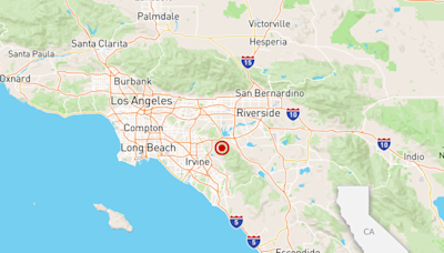
Where did the Anaheim earthquake occur?
How many earthquakes occur a year in California and Nevada?
What is quakebot & how does it work?
Earthquakes are shown as circles sized by magnitude (red, < 1 hour; blue, < 1 day, yellow, < 1 week). Click or tap on a circle to view more details about an earthquake, such as location, date/time, magnitude, and links to more information about the quake. Local time is the time of the earthquake in your computer's time zone.
- Overview
- Causes of earthquakes
Over the centuries, earthquakes have been responsible for millions of deaths and an incalculable amount of damage to property. Depending on their intensity, earthquakes (specifically, the degree to which they cause the ground’s surface to shake) can topple buildings and bridges, rupture gas pipelines and other infrastructure, and trigger landslides, tsunamis, and volcanoes. These phenomena are primarily responsible for deaths and injuries. Very great earthquakes occur on average about once per year.
What are earthquake waves?
Earthquake waves, more commonly known as seismic waves, are vibrations generated by an earthquake and propagated within Earth or along its surface. There are four principal types of elastic waves: two, primary and secondary waves, travel within Earth, whereas the other two, Rayleigh and Love waves, called surface waves, travel along its surface. In addition, seismic waves can be produced artificially by explosions.
How is earthquake magnitude measured?
Magnitude is a measure of the amplitude (height) of the seismic waves an earthquake’s source produces as recorded by seismographs. Seismologist Charles F. Richter created an earthquake magnitude scale using the logarithm of the largest seismic wave’s amplitude to base 10. Richter’s scale was originally for measuring the magnitude of earthquakes from magnitudes 3 to 7, limiting its usefulness. Today the moment magnitude scale, a closer measure of an earthquake’s total energy release, is preferred.
Where do earthquakes occur?
Earth’s major earthquakes occur mainly in belts coinciding with the margins of tectonic plates. This has long been apparent from early catalogs of felt earthquakes and is even more readily discernible in modern seismicity maps, which show instrumentally determined epicentres. The most important earthquake belt is the Circum-Pacific Belt, which affects many populated coastal regions around the Pacific Ocean—for example, those of New Zealand, New Guinea, Japan, the Aleutian Islands, Alaska, and the western coasts of North and South America. It is estimated that 80 percent of the energy presently released in earthquakes comes from those whose epicentres are in this belt. The seismic activity is by no means uniform throughout the belt, and there are a number of branches at various points. Because at many places the Circum-Pacific Belt is associated with volcanic activity, it has been popularly dubbed the “Pacific Ring of Fire.”
Britannica Quiz
April Showers to March’s Lions and Lambs
A second belt, known as the Alpide Belt, passes through the Mediterranean region eastward through Asia and joins the Circum-Pacific Belt in the East Indies. The energy released in earthquakes from this belt is about 15 percent of the world total. There also are striking connected belts of seismic activity, mainly along oceanic ridges—including those in the Arctic Ocean, the Atlantic Ocean, and the western Indian Ocean—and along the rift valleys of East Africa. This global seismicity distribution is best understood in terms of its plate tectonic setting.
Dec 21, 2022 · A 6.4 magnitude earthquake impacted Northern California's Eureka area early Tuesday, according to the US Geological Survey, leaving thousands without power. Follow the latest news here.


